I told you in the last Nugget that David Rohl had led two expeditions into the Sinai Peninsula in 2001 and 2004 with the intention of following the trail the Israelites walked while testing that trail against the walking pace needed to negotiate the route in the biblical time frame. Rohl’s plan was to identify the camp sites along the way and to track the most likely route the Israelites took during the Exodus. I would strongly recommend you get hold of his book Exodus: Myth or History if you are interested in the evidence for the Exodus journey. I also told you in the previous Nugget which I sent out two weeks ago that I would begin to look at the route David Rohl and his friends followed. However, those of you who have these Gems and Nuggets emailed to you were informed that I had some difficulties last weekend. I ended up spending the day in a Medical Centre and following that the hospital getting checked out for feelings nausea to make sure I was able to drive to a far-away prison to visit an inmate on Sunday. So my weekend disappeared. Now in this Nugget we will finally start following ‘David Rohl’s route’ from Avaris to Pi-Hahiroth. You have not missed anything; I just ran out of time last weekend.
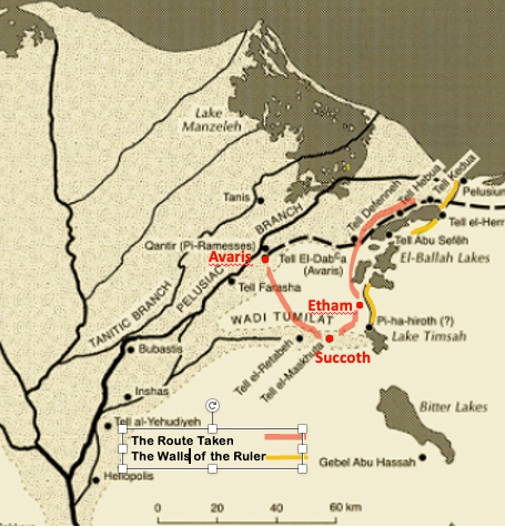
There are numbers of reputable scholars who are convinced that the Yam Suph was located among the large inland lakes on the eastern boundary of Egypt. There were numerous lakes between the eastern Wilderness of Suph and the northern Sinai desert. David Rohl is convinced that Moses would have led the Israelites along the traditional route to the Promised Land. His hunch was that Succoth would be found in the eastern region of Wadi Tumilat (Egyptian ‘Tjeku‘). Archaeological evidence had been found there for Semitic people in the Mid Bronze period. It appears there was a large population of Hebrew slaves there at a place called Tel el-Maskhuta. Rohl has suggested it was very likely that Moses picked up a number of slaves there, southeast of Avaris, and added them to the band of Israelites.
From there they headed to Etham. Most scholars think that Etham was near Lake Timsa (the Crocodile Lake) close to the modern city of Ismaliya. Heinrich Brugsch first proposed this route in 1868 and many others, like Kenneth Kitchen, think Etham was likely [iw Itm] or the Isle of Atum in this area. This region is well known for canals 70 metres wide dug during the time Amenemhat (12th Dynasty) and used as a part of the defensive network of the Egyptian pharaohs on the eastern border. The canals were interlaced with fortresses called the Walls of the Ruler to protect the eastern border. Seti I has a relief a Karnak depicting him crossing the canal via a bridge over crocodile infested waters on his way back from the campaign in Canaan. There are numerous forts in this area, including one called Migdol, “Fort”.
David Rohl as a result of his expedition, undertaken to replicate the original Exodus, has gathered evidence as an archaeologist, Egyptologist and someone who has looked into the linguistic similarities between toponyms (place names) in the area across various ancient languages. The results are compelling, convincing me to reopen the possibility that the inland lakes in the North Eastern corner of Egypt may well hold the key to the Yam Suph and evidence for the Exodus. My hesitancy in the past has been the lack of evidence and the improbability that the Israelites would head in that direction. In my mind there was nothing forcing them to cross one of the lakes. Why cross a lake when you can walk around it. But I was unaware of the Walls of the Ruler.
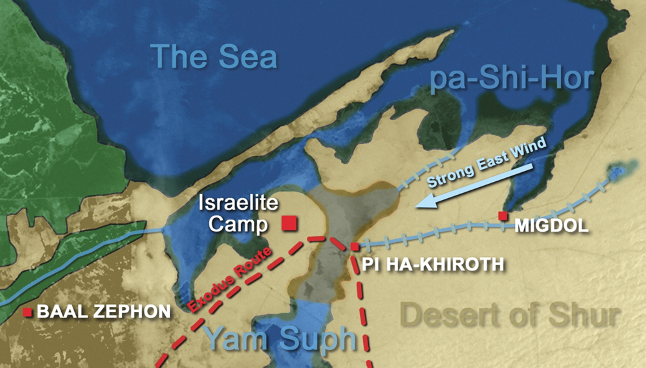
According to David Rohl the configuration of the topography and the presence of the Walls of the Ruler provide the key to understanding how the Israelites would have been trapped against the waters of the Ballah Lakes. The two canals marked on Rohl’s map give the confluence between the canals which resulted in the name Pi-Ha(k)hiroth. The full extent of the Walls of the Ruler are not marked on this map but they are on the first map above. The shaded muddy looking area in this map, according to David Rohl, is the extent of the dry ground remaining as a result of the Strong East Wind. All the pieces fit, but there are more treasures hidden in David Rohl’s book.
Rohl’s research matches that of others in terms of some of the key places and toponyms. Tel Defana is a few miles from the position David Rohl marks for Baal Zephon on his map. William Allbright was the first to suggest this site as the location of Baal Zephon. David Rohl outlines a full account of the linguistic evidence for the toponyms in the area and provides convincing evidence for the link between them all. These include not only Migdal Baal Zephon but also Yam Suph (Hebrew), Sefa (Arabic), Pa-Tjuf (Egyptian). The following scholars all substantiate these facts – Allbright, Hoffmeier, Gardiner, Brugsch, Bietak et al. There is extensive further evidence in David Rohl’s book, which is why I suggest if you are interested to investigate further, you ought to buy the book as I have done. I am not going to plagiarise David Rohl’s detailed material any further except to add this segment.
In January 1882 Major General Sir Alexander Tulloch was inspecting the Suez Canal. He witnessed “a wonder of nature” as the 5 foot deep waters of Lake Menzala literally disappeared. [In Tulloch own words] “An easterly gale came up very rapidly and, at last was so strong, driving the sand from the dry side into my face that I had to stop work. Next morning . . . I went onto the canal bank again, when, to my astonishment, I noticed that Lake Menzala on the west side of the canal had disappeared beyond the horizon in that direction, and that the Arabs were walking on the mud where the day before large boats had been floating. When thinking over this extraordinary effect of wind on shallow water, it suddenly flashed upon me that I was witnessing a similar event to what which had taken place between three and four thousand years ago, at the time of the passage of the so-called Red Sea by the Israelites.”
David Rohl suggested in one interview for Timothy Mahoney’s film series Patterns of Evidence that he was open to the possibility of someone presenting him with a chariot wheel from the Nuweiba Crossing point. He issued the challenge to proponents of Route 5 – “Bring me up one chariot wheel from the sea and I will be convinced.” David Rohl suggests that it would be worthwhile to investigate the area shaded on the map above in terms of what lies beneath the surface.
I will continue the journey in the next Nugget. In the meantime we will camp a week at the Ballah Lakes.
Yam Suph, the “Walls of the Ruler” and the strong east wind absolutely fascinating reading Professor!