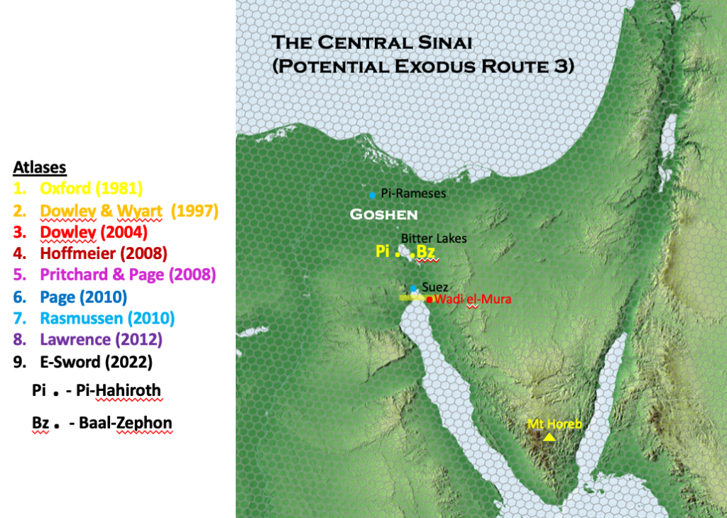
The Central Sinai Route as proposed by Simons, Condor, Cassuto and John David appears to differ only at the point of crossing. Not only that but they were divided between themselves as to whether the crossing between Pi-Hahiroth (Pi) and Baal Zephon (Bz) took place at the Bitter Lakes or at the northern end of the Gulf of Suez. I have not been able to find any details on the credentials of these four proponents, neither are the on-going points in the journey marked out for us. Because they have chosen a Central Sinai route one can only assume they followed the standard route marked out by most researchers in the crossing the Central Sinai desert. But we have seen already, there is great variation between the locations chosen across the range of Bible atlases. As a result it is very hard to pin-point the exact route which these four proponents chose.

The points of reference they delineated I have placed on the map above. In order to construct this version of the route taken, I imagine we are to assume a route similar to Hoffmeier’s map which I gave you in the last Nugget. That route is the standard route suggested after crossing the body of water between Pi and Bz. What is curious with this proposed route is why the Israelites would need to have crossed the Bitter Lakes. Why would they not have just simply gone down the eastern side of the Bitter Lakes and not had to cross a body of water at all. That is the option that many researchers choose under the traditional route where no body of water has been crossed at all.
The other site for the crossing suggested under this theory is just to the south of the modern city of Suez. I will pick up the detail on this suggested crossing when we look at the next option of the South Central Route proposed by Livingstone et al. But at this stage suffice to say, I think the theory of these four researchers (Simons, Condor, Cassuto and David) was first put forward by Edward Robinson and Eli Smith from their expedition in 1838. Robinson was known as the father of Biblical Geography. [One of the Herodian arches leading to the Temple Mount is called the Robinson Arch.] Eli Smith was a reknown scholar of Arabic. These two had some pedigree in this field of research.
Some believed back then that the Red Sea crossing took place just behind the town of Suez to the north. Robinson observed two long parallel banks approximately 36 metres apart, marking the course of an ancient canal. Robinson and Smith were able to pass into the Wilderness of Etham because the banks were dry and passable in 1838, camping the first night close to Wadi el-Mura. (See the above map). The thick yellow line I used to locate the vague possible crossing point to the south of Suez. In my opinion the idea of the Israelites crossing at this location is highly unlikely. Why would they come to the northern point of the Yam Suph (Red Sea) and cross a short distance away from the northern point of the start of the Red Sea when it was apparent they could simply go around the north point at Suez on dry land. It makes no sense.
The rest of the journey is unspecified according to this theory and tends to merge with the Traditional Route which you can see in Gem 2062 on Tim Dowley’s purple route. Therefore I will leave any further comments or description on this theory as I believe I have covered the main points and discounted it.
