I am continuing to address the difficulties surrounding the places involved on the Exodus journey to Sinai and beyond. I have told you before in both Gems and Nuggets that I am wanting to investigate the difficulties involved in the Exodus journey. I am particularly interested in the questions which remain relating to the places mentioned regarding the Exodus journey. In the Gems I am tracking the route with particular reference to the places of the Israelites’ rebellion. But here in the Nuggets I want to resolve some of the questions I have long kept in mind in order to resolve them at the right time. Well I believe now is that right time.
Two of you have already come up with questions related to the order I have given you for each of the places of rebellion. Their question related to the placement of Sinai at the top of the list of places of rebellion. “Ian, why did you place Sinai at the top of the list of the places of rebellion? I get why you see it as a place of rebellion. That much is clear to me from what you have given us on what happened at Sinai. But what confuses me is why you see Sinai as being first? Surely all of the places of rebellion came before Sinai, not after it. Please explain.”
Our List of the Places of Rebellion in Order
- Mt Sinai
- Taberah
- Marah
- Rephidim
- Kibroth-Hattaavah
- Hazeroth
- Kadesh Barnea
It is quite possible that you missed the clue as to why I am doing this. Perhaps it was too subtle. I will give you again what I gave you in Gem 2061.
They marched for three days after leaving the mountain of the LORD, with the Ark of the LORD’s Covenant moving ahead of them to show them where to stop and rest.
Numbers 10:33
Soon the people began to complain about their hardship, and the LORD heard everything they said. Then the LORD’s anger blazed against them, and he sent a fire to rage among them, and he destroyed some of the people in the outskirts of the camp. Then the people screamed to Moses for help, and when he prayed to the LORD, the fire stopped. After that, the area was known as Taberah (which means “the place of burning”), because fire from the LORD had burned among them there.
Numbers 11:1-3
You can see from Numbers 10:33 that these other places came after they left the mountain of God (Mt Sinai). Now that is interesting to say the least. It has had me puzzled for a number of years. I have been encouraged by a number of mentors over the years to hold on to my questions and keep bringing them before the LORD, asking for enlightenment. As Einstein once said, “It is not that I am so smart but I stay with the questions much longer.” So this is one of the questions I have hung on to.
I have taken you through the places of rebellion, primarily in the context of what the writer to the Hebrews gave us. However, I also have a bunch of other questions I would like to resolve which are not so focused on the places of rebellion but on other aspects of the Exodus journey. I have established already that there are multiple locations given in the maps for Sinai, Rephidim / Meribah / Massah, Kibroth-Hattaavah and Kadesh-Barnea. There is another place we need to investigate regarding multiple locations which I have drawn your attention to in Gem 2063. The place in question is Pi-Hahiroth. Pi-Hahiroth together with Baal Zephon are the two places either side of the crossing over the sea of reeds or the Red Sea.
Just look at the map I gave you in Gem 2063. I have posted it again below for your convenience in order to keep all evidence before you in a way that you can compare it.
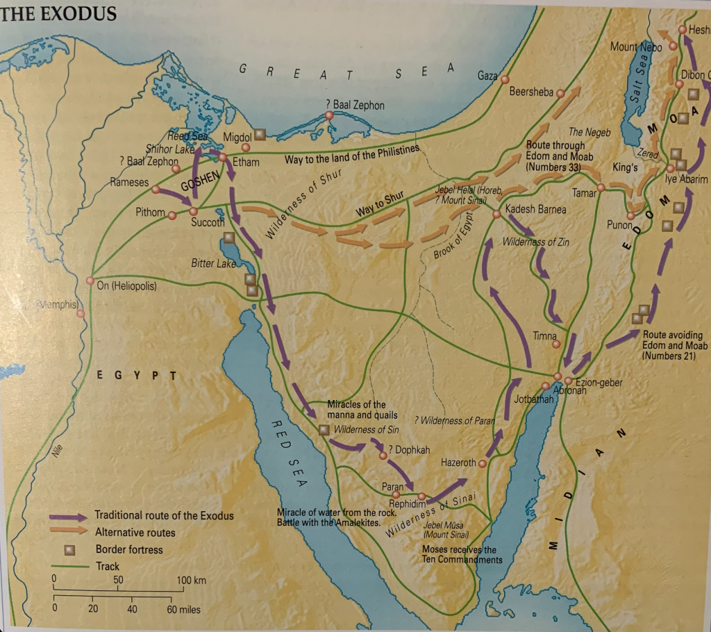
The positioning of these two places, Pi-Hahiroth and Baal Zephon, mark the location of the crossing point. So these two markers and the body of water between them are crucial evidence of the likely location for the point of crossing over the Yam Suph. Hence in Gem 2063 I pointed out the vain attempts to locate these two places in the north. It makes no sense to look around the coast of the Mediterranean as indicate on the map above. It also makes no sense to look in the area of the Faiyum and Lake Moeris as mentioned in Gem 2063. If indeed Lake Moeris was created by Jospeh’s work in Egypt then the Israelites would have known it was a lake and gone around it. The same is true of the smaller and larger Bitter Lakes marked on the map. God doesn’t have to engineer a miracle if the people of Israel can simply walk around a lake; it makes no sense.
So a glance at the map above leaves you (and me) asking one major question, doesn’t it? So which body of water did they cross over in Exodus 15? As you can plainly see, there is no body of water impeding their progress whatsoever. So there was no need for a miracle where ‘the horse and rider were thrown into the sea‘. That will please the people from the Jesus Seminar at least, who delight to demythologise the Scripture. In other words take out all the miracles as being impossible so therefore could not have occurred. That brings us to any maps which take into account the material from Lennart Möller, The Exodus Case.
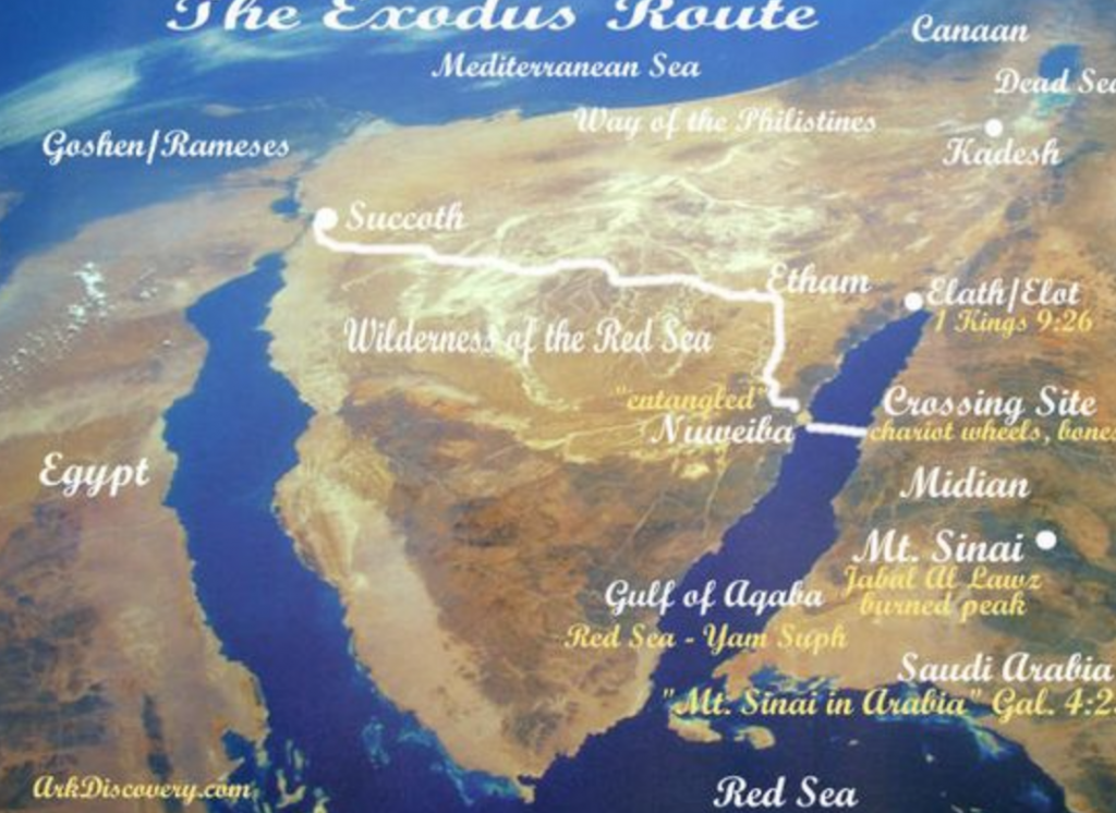
This map was not generated by Lennart Möller but was rather produced by Ron Wyatt on the Ark Discovery website. Frankly, Ron Waytt’s material is not reliable and should not be consulted, however it is the only map I have seen which takes into account the material found written in Lennart Möller’s book The Exodus Case. However I wouldn’t position the journey to Nuweiba in the way this map has.
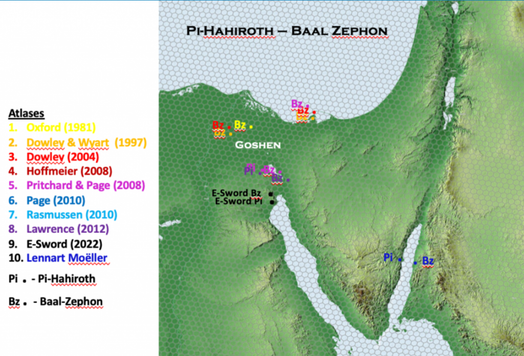
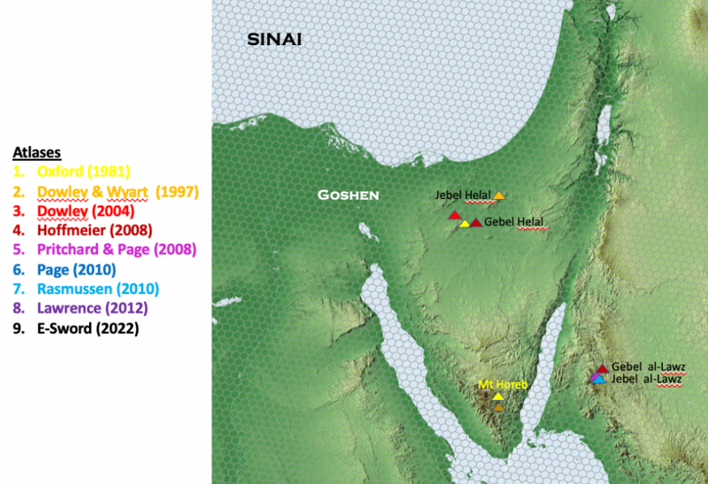
Now let’s match this map with the one I gave you in Gem 2063 for the alternative locations for Mt Sinai. You will notice in the map below of the alternative sites of Mt Sinai that Mt Gebel Al-Lawz is nicely placed to access from the crossing point from the Plain of Nuweiba and the subsequent positioning of Pi-Hahiroth and Baal Zephon from there.
I am sure you are beginning to see where I am heading. As a result of me giving you a whole lot of information to put together I will take a break and give you time to pull the pieces together. We will continue our investigation again in the next Nugget which as usual will go back to the normal Saturday time slot. In the meantime you have a lot to ponder.
why have you again referred to ‘the sea of reeds or the Red Sea?
Why do you think? What is it exactly that you are querying?
Dr. Barry J. Beitzel, in The New Moody Atlas of the Bible, 2009, page 107, has a map showing the crossing of Yam Suph at Lake Timsah, Egypt.
This map does not show a Pi-ha-hiroth, but he discusses the site on page 108:
“From Etham, the Israelites arrived at Pi-ha-hiroth…wherever the place is, it must have been immediately adjacent to the body of water through which Israel crossed.”
From that statement, I find it strange he does not show a Pi-ha-hiroth on his map titled “The Israelites leave Egypt” on page 107.
Beitzel, page 109:
“…it seems most plausible that the divine crossing of the sea…took place at or near Lake Timsah, where the established transportation artery (“the way to Shur”) intersected a line of lakes [see map 33]…”
His map shows “the Way to Shur” passing by the north shore of Lake Timsah, then continuing down Wadi Tumilat to the Delta.
So, for Beitzel, the fact that “the way to Shur” begins at Hebron, then goes to Beersheba, then to Mueweliah, then across Sinai, to Lake Timsah (called by the Arabs the Darb el Shur), thus locates Yam Suph.
Other Bible Atlases have the Darb el Shur ending at Timsah.
I suspect Beitzel is right, Yam Suph is Lake Timsah (Arabic: Birket Et-Timsah, “the lake of the crocodile”).
Not noted by Beitzel, is that pre Suez Canal maps, pre 1860, show LakeTimsah to be split in half by a narrow land corridor, running from west to east. Canal dredging has done away with that corridor, it no longer exists today.
It is my proposal that this corridor is what is behind the notion of God providing a dry land corridor for Israel to walk on in the midst of Yam Suph.
To view this corridor today, google Lake Timsah, then click on “images” at the top of your screen, then scan through the images presented until you find an image labeled “Lake Timsah 1885.” This 1885 map is a copy of an earlier pre 1860 Lake Timsah map, before its having being done away by dredgers.
As for “the way to Shur” (Hebrew Shuwr) I note a site called Bir Abu Suweir, a well, on the Darb el Shur, just west of Ismailia, being the Bible’s Shur. That is to say Shur is not a wall, its a well.
The Darb el Shur continues on from Bir Abu Suweir to the Delta, ending at Bilbeis, on a map survey of circa 1796 by Napoleon Bonoparte’s Corps of Engineers.
So, where is Pi-ha-hiroth?
I suspect it is Tel el Maskhutah, identified today as being either Succoth or Pithom.
A Ptolemaic stone stela of the 3rd century BC by Ptolemy 2, found at Maskhutah, calls Maskhutah Hero-polis, the city of Hero, probably from Egyptian hrw, Heru, Horus?
Ptolemy claims to have visited the site to inaugurate a new temple he has built called Pikeret.
I note Pi-ha-hiroth, in Hebrew, is pronounced Pee-kha-roth.
Perhaps Ptolemy II’s Pikeret is the Hebrew sounding Pee-kh-erot?
If so, then Hero-polis may be an abbreviated form of Ha-hirot? A verse in the Bible renders Pi-ha-hirot as Ha-hiroth.
That is to say the hiro or hiroth wa preseved as Hero?
The site’s has pottery of circa 1530 BC and the Hyksos. Then a 1,000 year abandonment, then resttled circa 610 BC by Pharaoh Necho II, who is building a canal from the Nile to the Gulf of Suez, via Wadi Et-Tumilat.
If all, the above is correct, the Exodus account is probably of the 7th century BC. Ether that or the 16th century BC Hyksos Expulsion, being recast as Israel’s Exodus.