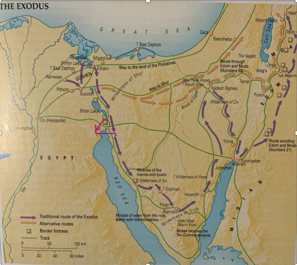
This route is also recognised as the Traditional Route for which I have given you a map already in Gem 2062. But instead of just giving you the link I will add Tim Dowley’s map again so you have it before you in this Nugget. I also need to add something to the map to explain the most significant variation under this theory. But first I wish to address the issue of the multiplicity of theories and minor variations on the route. I have adopted the system of classifying these routes given by Livingstone and the researchers at the Association for Biblical Research who came up with five routes to which I have added a sixth option and am likely to add a seventh. It just keeps growing.
In this case however I am combining the ABR South Central Route with the Traditional Route because there is a just a slight variation between the two. Yet a variation which I have discounted under Potential Route 3. You will notice I have added a feature to Tim Dowley’s map. The thin curved pink line just under the northern end of the Gulf of Suez on the map below. Livingstone and folk from ABR include the Suez crossing talked about with Route 3 to the options. In the chart the Nugget Investigating the Six Main Theories you will notice there is a dual option under the Crossing Point in my table. ABR et al include in this option a crossing point between Ras el-‘Adabiya on the western side of the Gulf to Birket Misallat on the eastern side. I really don’t understand why they would do that. It just makes no sense as I have stated in my evaluation of Route 3. The idea comes from the work of Robinson (the Father of Biblical Geography) and Smith after their journey in 1838. So I guess it remains an industry standard but it has since been discounted by David Rohl and others. You can see I have accounted for this alternative in the map I have modified from the one found in Tom Dowley’s atlas.

Of all the maps used which follow the Standard Route, there are slight variations in location for the journey across the Wilderness of Sin to the Wilderness of Sinai. The location of the arrows marking the journey across the Sinai Peninsula vary between coming out as far north as the location of Jotbathah on the Gulf of Aqaba or as far south as Tim Dowley’s thin green line running between Paran and Rephidim in the map above. Suffice to say there is great variance but you get the general idea. The term South Central Sinai Route sums it up pretty well. The destination for all options under this route is of course Jebel Musa, the choice for Mount Sinai.
I have two problems with this route depending on where the placement of the two initial camps are placed after leaving Rameses (Avaris), i.e. Succoth and Etham. Where these two camps are placed determines the location of the crossing point and the distance of the journey to the crossing point. This holds huge significance for the other factors which determine the overall route. The timing of the journey from Rameses / Avaris to the crossing point – the days needed and the order of the camps afterward. They are two of my gold standard measures. More will be said about that under theories still to come. It all has to fit together; what Tim Mahoney calls Patterns of Evidence.
I have not added the locations of the key camps to this map which differ under the ABR option simply because I haven’t been able to find them located on a map from any resource from ABR. No doubt if I purchased a series of resources from ABR I could do so. But I have spent a considerable amount on resources which I consider more valuable for this investigation. Each of the proponents of these theories have their own set of videos and books and other resources for purchase. I prefer to sound out the overall differences in their theories first before investing more. Suffice to say the South Central Sinai Route fits the Standard Route apart from the different crossing point at Suez and locations of Succoth and Etham. The last mentioned camp, Etham, is an interesting marker together with Migdol as to where any new theory places any of the camps with follow. The different locations given for these two places are surprising under some of the theories. Furthermore, I have found all material I have come across so far from the ABR proponents to be mainly focused on the criticising the proponents of other theories rather than marking out the route with each camp in the location they think the camps to have been. Until I see maps like that it is hard to evaluate the specific details of their theory. The crossing point is only one gold standard marker in the quest for determining how likely each theory is for us to accept as being a valid one.
I am sure you can tell from what I have said to this point that I don’t see any noteworthy features under the South Central Route which require further comment apart from the strange Robinson – Smith crossing point already mentioned. Following this theory, Theories 5 and 6 are the two which place Mt Sinai at the location of Gebel al-Lawz. Now that will be interesting. A number of my readers have commented on what they think about these new theories which float the idea of Mt Sinai being Gebel al-Lawz in ‘Saudi Arabia’. Let’s investigate.
