By now, you are well aware of the complications of tracking the Exodus Route from Rameses to the entry point of the Israelites to their Promised Land in Canaan. I have quoted the words of William Dever and K.A. Kitchen for you before, “Any attempt to map the Exodus route is doomed to failure, especially where the locations of the places following Sinai are concerned. There is just too much conjecture involved.” With the help of David Rohl and Timothy Mahoney’s work and others we have managed to get as far as Greater Kadesh or Petra. Now we are faced with the final approach to the borders of the Promised Land: the final nine toponyms listed in Numbers 33 as the names of each camp in this final part of the journey.
- Mount Hor
- Zalmonah
- Punon
- Oboth.
- Ije-Abarim, on the border of Moab.
- Dibon-Gad
- Almon-Diblathaim.
- In the mountains of Abarim, before Nebo.
- On the plains of Moab by the Jordan, [near] Jericho, from Beth-Jeshimoth as far as the Meadows of Acacia)
It all sounds so detailed and specific, doesn’t it? Just follow the map people! But you have seen already that there are many maps. As a result of my desire to map this journey, I have now added two more atlases to my collection of atlases and reference books for the historical geography of the Bible, so that they now number 14 in all. My desire to work out the most likely route involved far more than I anticipated and as a result of delving into the complexity I have become wiser as to the challenges involved. It is little wonder that there are so many theories as to the route taken; it is complicated. The locations post-Sinai are the trickiest given the multiplicity of toponyms used. This is the part of the journey with the most disparate differences in the atlases and reference sources as to the place names and the location of each. Hence the classic quote by Dever and Kitchen mentioned above. We have come down to the last nine toponyms and on the face of it they seem very specific and clear cut. We are on the home straight. Paul H Wright, in the Then and Now Bible Map Atlas (Rose Publishing: 2012) wrote
The journey of the sons of Israel to the land of promise finally led them into Transjordan. Here the itinerary is more certain, as many of the place names on the route have been identified (Num 21:10-20, 33:41-49; Deut 1:1, 2:1-5, 2:8, 2:13-14, 2:24, 3:1, 3:8-17, 3:27-29).
Paul Wright
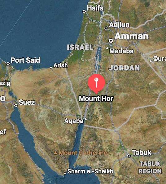
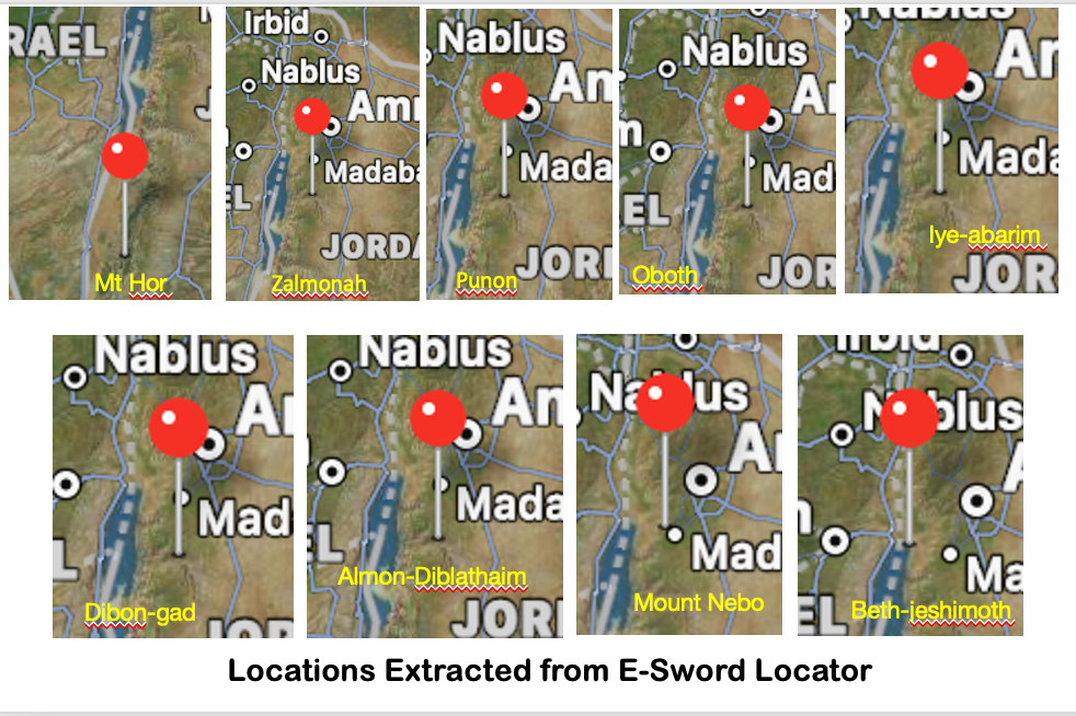
The journey from Pi-Rameses to Canaan took 2 years (Num 14:33, Deut 2:14). Yet Pharoah Nico’s army marched across the Sinai via the Horus Way in two weeks. Well, it was easier for a fully equipped, trained army than a large number of fleeing refugee slaves of all ages. God also used the journey to work Egypt out of His people in order to test their trust and willingness to obey His every command. I smiled when reading the comment above by Wright. Previously, I had made use of the E-Sword Location feature recently added to the programme. If you highlight a place name in E-Sword then it will give you a map of the place name in focus when you click <Locate “X”>. Here then are the results for these last nine toponyms. Starting with the first toponym in our current list (Mount Hor) to give you the scale, I have then included all nine locations below in smaller snapshots.


I am sure you will come to the same conclusion I did. At best this new tool in E-Sword is a general guesstimate only. It is by no means an exact science. From the locator tool in E-Sword we gain the impression that the six toponyms from Zalmonah to Almon-Diblathaim formed a cluster with all 6 places virtually on top of each other. [At least that way they would not have had to pack up camp each night and move on.] I have written to Rick Meyer who created E-Sword to query the method behind the locator tool.
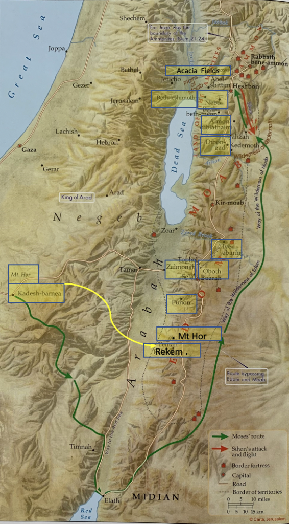
Among the numerous maps I have from the multiple atlases in my library, this new atlas from Paul Wright has the closest map for this last series of toponyms involved in The Final Approach to Canaan. It is not that it matches my thinking and what I extrapolate to fit David Rohl’s concept exactly but I think it comes closest. Take the time to look at it for yourself and you will find some discrepancies.

You will have noted I am sure that the locations of Kadesh Barnea and Mount Hor are placed according to the traditional route further west. Wright has not taken into account the route we have been tracking. If David Rohl’s input were taken into account, Kadesh Barnea would equate with Rekem on this map. Wright includes Rekem but I have made the toponym larger to make it stand out. From that point we have a curious switch in the order of Punon < and > Zalmonah, following which the list of places from Numbers 33 follows in order:- Oboth, Iye-Abarim, Dibon-Gad, Almon-Diblathaim, Mount Nebo and finally Beth-Jeshimoth on the Plains of Moab. You will note that I have added Rekem and Mt Hor in a new position with larger print to make clear what I have added to Paul Wright’s map. I changed the name from Meadows of Acacia to Acacia Fields as one translation calls it. The scale of the space needed for the Israelites to camp on the Plains of Moab is likely exaggerated but I needed to fit the extra toponyms in a clear way. The scale and locations of the toponyms on Paul Wright’s map don’t match perfectly the locations according to the relative distances between each toponym in focus but it will suffice at this stage. At least it is the closest map I have found from all those available to me in the sources I have in my library and it gives us a nice pictorial summary of the final part of the journey.
By taking the King’s Highway through the eastern desert route Moses avoided any conflict over the grazing of livestock. There was adequate pasture and water in the upper reaches of the Zered (Wadi el-Hasa) and Arnon Valleys (Wadi el-Mujib). Opposite the northern end of the Dead Sea, Moses and the Israelites turned toward the West and the Plains of Moab, by going through the Medeba Plateau. It was in the buffer lands between Moab, Ammon and Canaan that the Israelites encountered King Sihon and subsequently they descended to the Plains of Moab. I am not suggesting by adding the location for Acacia Fields (the Meadows of Acacia) that the Israelites spread out over the entire plain. I added it to make the location clear. However, the facts do match with the scale of the crossing of the Jordan River recorded in Joshua 3, where it’s mentioned that the waters were stopped at Adam, 20 plus kilometres from the Ford of Jericho. All the pieces fit, leading me to conclude this is the most likely route taken by the Israelites from start to finish; from Pi-Rameses to the Jordan River.
But as mentioned along the route in the Nuggets I have written, like David Rohl I would willing adjust my opinion, if more evidence came to light. However, given all of the facts and the most likely scenarios covered in all seven theories related to the Route of the Exodus I believe what I have given you in this Nugget series to be the most likely.

What a fantastic effort on your part Ian it is a truly amazing outcome.
Thank you Ross. Yes I didn’t imagine it would have taken me what it did but I kept having to deal with new issues along the way. But yes now it is done. I will take time out from the Nuggets now until we have made good progress in getting Deeper Bible redeveloped as an Online Course. From time to time I may add one-off-Nuggets when I come across something that I just have to comment on.
Thank you Ian for an incredible journey
Thank you Ken. I am glad that you read this series all the way to the end. Glad that it blessed you.
Ýouve put in a grand effort thank you. I feel sad that it’s no definitive. But I guess that there wasn’t alot of paper around.
Kev