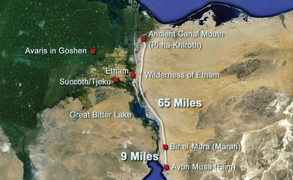
One of the aspects of David Rohl’s research and approach that I most admire is his intention to map the Exodus journey according the times specified in the biblical text. The expeditions he undertook in 2001 and 2004 was with the expressed purpose to see if they could make the journey in the time frame given in the Bible. Others who had walked it before were Robinson and Smith in 1838 and Charles William Wilson in 1881 by camel. Although David Rohl and friends used 4WDs to do the journey and carry the equipment they took with them, they were still intent to calculate the time taken by a group the size of Moses and the Israelites walking the journey. Wilson (1881) estimate that he was able to keep up a pace of 2.75 miles (4.5 kms) per hour. Ancient records concerning Egyptian and Roman armies estimated a journeying time of between 15-20 miles (24-32 kms) per day. Josephus informs us that the Roman army travelled along the coastal Sinai route at an average of 26 miles (41 kms) per day. David Rohl calculated a pace of 22 miles (35 kms) per day for the journey they took bearing in mind the journey in focus here was made by a much larger group of women and children and was likely made at times at night when it was cooler.
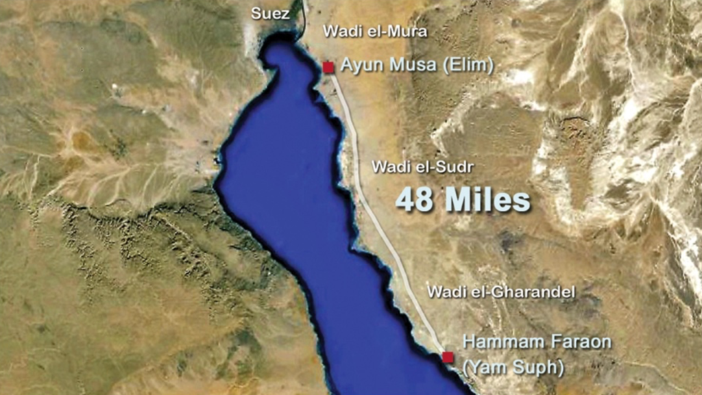
After making the crossing to Pi-Hahiroth, they travelled down to Elim which according to Rohl took 4 days. There is no record of the timing for the journey from Marah to Elim as it likely took just a single day. Ayin Musa is just 9 miles (14 kms) to the south from Marah. According to Rohl, Gregory Mumford (an Egyptologist at Toronto University) and Menashe Har-El (an archaeologist at Tel Aviv University), Elim is most likely to be Ayin Musa. All the details of the biblical text fit modern day Ayin Musa. Until recently most researchers considered Ayin Musa to be the location for Marah. But largely that was because these researchers (like Livingstone, Robinson and Smith et al) believed the crossing point was just south of modern day Suez. David Rohl states the journey from Bir el-Mura is a three day journey at a pace of 22 miles (35 kms) per day. Pa-Tjuf to Marah the Bible records as a journey of 3 days, leaving the journey from Marah to Elim. Therefore, Ayin Mura is a better match for the location of Elim.
From Elim the text of Numbers records the journey from Elim to Dophkah.
They left Marah and camped at Elim, where there were twelve springs of water and seventy palm trees.
They left Elim and camped beside the Red Sea.
They left the Red Sea and camped in the wilderness of Sin.
They left the wilderness of Sin and camped at Dophkah.
Numbers 33:9-12
At this point the possible routes for the Exodus journey that we have covered prior to this have all kinds of ideas as to where Dophkah is and which place is represented by Dophkah. Some like Steve Rudd’s route have the Israelites continuing on down the coastal route to the south all the way to the Straits of Tiran. The timing for such a journey is a sheer impossibility given the time frame set by the biblical text. The traditional route (Potential Route 4) has the Israelites turning inland away from the coast to pass through Serabit el-Khadim or Sarbut al-Khadem as I have mentioned in past Nuggets. For me this is a gold standard location and must appear somewhere along the route for the Exodus journey. But we do have the curious second mention of the Yam Suph or camping by the shores of the Red Sea.
The text of Exodus doesn’t describe the timing of the journey from Elim to the Wilderness of Sin. Only Numbers 33 covers that without any indication of time taken. Exodus simply states the journey to the Wilderness of Sin took one month from when they left Goshen to the 15th day of Second month. David Rohl and team went down to Hammam Faraon and from there left the shores of the Red Sea and headed inland away from the sea through Wadi e-Waseiyit (Robinson’s Wadu Useit) to the head of Wadi el-Tayiba. Rohl then took an unmade track to the east off the main road where they entered a gorge cut between 45 metre high limestone cliffs, through a pass that led to Wadi el-Humr. After passing Gebel Sarbut el-Gamal they reached the sandstone region of the Wilderness of Sin. Rohl and his team passed another narrow gorge with Nabatean inscriptions carved on the rocks. They then entered the widest part of the Wadi e-Humr (Debbet el-Kerai), a broad sandy valley. David Rohl feels it was here that the miracle of Quail and Manna occurred. Exodus 16 informs us that the Israelites remained in this area for a week. Rohl and his team pressed on into the Wadi el-Nasb beyond into Wadi el-Murak and camped at the foot of Serabit el-Khadim. Ah, now I am satisfied. According to David Rohl Serabit el-Khadim is the best fit for the location of biblical Dophkah.
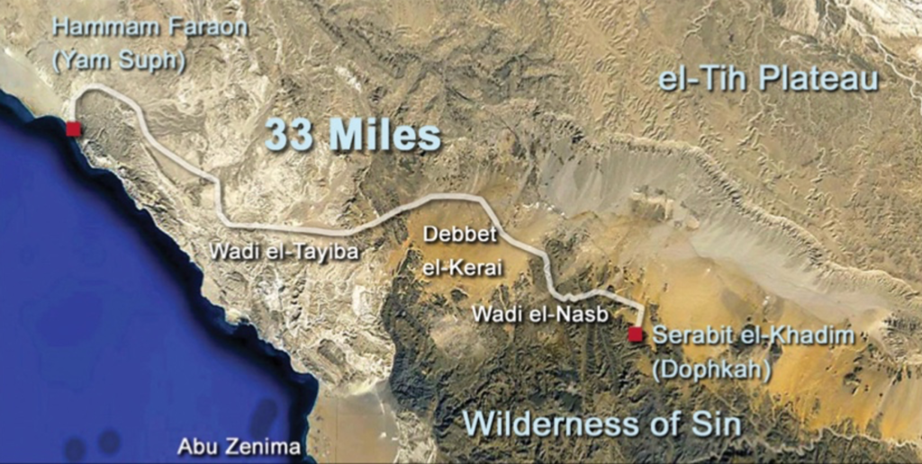
The cliffs to the north are the escarpment face of the el-Tih plateau beyond which are the mountains of Serabit el-Khadim and Sinai. This is the site of Dopkhah. The distance between Gebel Hammam Faraon and Serabit el-Khadim is 33 miles. There are many water sources which exist in this area. From the Serabit plateau you can look across to the Temple of Hathor and the turquoise mountain, first exploited by King Sneferu in the 4th Dynasty. The major mining of turquoise work was done in the time of Amenemhat III. Flinders Petrie says the peak activity for turquoise was during the time of Amenemhat III who according to David Rohl was the Pharaoh during Joseph’s time. The name of one official on the statue of Senuseret III (Amenehat III’s co-regent) is Levi. Many of the mine workers have Semitic names. This is the place where inscriptions were found at Sarbut al-Khadem according to Grant Jeffrey. It is also the place where the first consonantal alphabet in history was created according to Orly Goldwasser and Douglas Petrovich. This latter feature is something I intend to pick up on with a future Nugget series. Like Timothy Mahoney suggests, it is all about patterns of evidence, where multiple factors and facts come together resulting in a strong unified case.
I will leave you at this point camped on at the edge of the el-Tih plateau at Serabit el-Khadim, Sarbut al-Kkadem or Dophkah. Call it what you like; it’s the same place. Don’t worry I won’t leave you in the wilderness. We will continue the journey in the following Nugget.