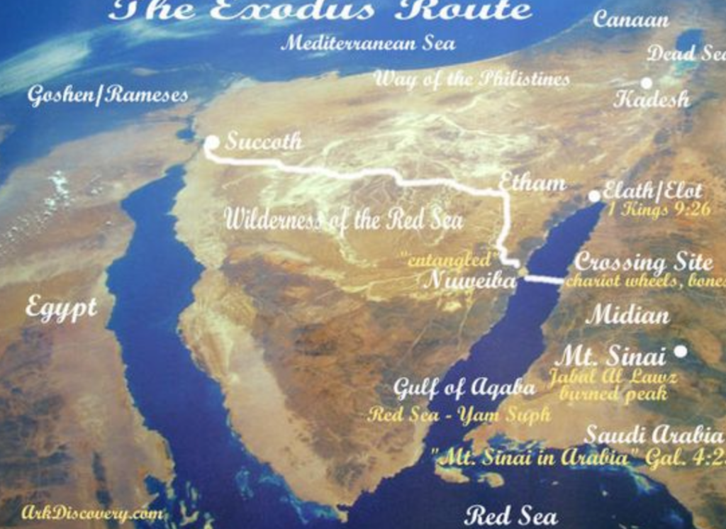
You will note that I have added Nuweiba to this 5th Exodus Route to distinguish it from the 6th one. This is quite typical of the routes of the Exodus in that it does not add any place names after the crossing apart from the location of Mt Sinai in relation to their choice of Gebel al-Lawz. I have told you already “there are several experts who claim this is a futile exercise because “any attempt to map the Exodus route is doomed to failure”, especially where the locations of the places following Sinai are concerned.” Many of these experts are highly skeptical of attempting to map specific locations especially after Mt Sinai. But under this suggested route there are a number of people who are loathe to attempt any locations after the crossing between Pi-Hahiroth and Baal Zephon as marked in my earlier Nugget series Evidence for the Exodus.
- Found at Nuweiba
- What Was Found Between Nuweiba (PI-Hahiroth) and Saraf al-Bal
- Evidence for a Chariot Crossing
This South Eastern Nuweiba Route would appear to provide conclusive evidence for a very significant case for the most likely route for the Exodus. That would certainly have been my conclusion before doing all of the latest research I have recently undertaken. I have given you the map below in a previous Nugget but I am not going to bother telling you which Nugget it was because it doesn’t matter. Here it is again.

Although I don’t particularly like this map, it is honest from the point of view of not mapping a route after the crossing site. It is my stated aim to present you with a comprehensive map indicating the most likely route after all of my research into this challenge. In terms of the Nuweiba crossing this one is probably the most honest. Despite the fact that Goshen / Rameses is not written on the land of Egypt but rather is written on the Mediterranean sea, it has delineated the area rather than the city of Rameses / Pi-Rameses / Avaris. I have deliberately left this map as it has been produced and have not added the location of the city the Israelites left. You can find Avaris in any of the other maps I have given you. This map does provide locations for Succoth, Etham and Nuweiba but not Pi-Hahiroth or Saraf al-Bal / Baal Zephon. The two places, Pi-Hahiroth and Baal Zephon, are where the red granite columns have been found as I discussed in the second Nugget with link referenced above.
No-one likes to refer the proponents of this theory. In the table I gave you for the Six Main Theories I only listed Lennart Möller at first. I have since added the name of Ron Wyatt whose name is almost a dirty word. The reason is the location of the crossing at Nuweiba is surrounded with controversy because it is strongly linked to Wyatt who first flew in a small plane over the area in 1986 and found the likely site of Wadi Watir and the broad plain of Nuweiba. Ron Wyatt had laid prior claim to finding an extraordinary number of locations of Biblically relevant sites, yet most of them remain unsubstantiated and linked with conjecture at best. When asked for proof related to any of the claims he made, Wyatt always had either a plausible or an implausible reason why he couldn’t produce any evidence. Hence when Ron Wyatt’s name is included in list of proponents it is synonymous with relegating that theory to the realm of unsubstantiated myth. However this site has been investigated by many searchers. Lennart Möller is the author of the book The Exodus Case. Möller and his team dived in the area to attempt to locate the evidence as had Wyatt and his team on numerous occasions. The main difference between the two was Möller adopted a sound scientific approach to the search. The main limiting factor has been a restriction placed on anything found in the area not to be removed by order of the Saudi Arabian government.
I am not going to add anything more at this point to the issue of what has been found in the sea off Nuweiba in the Gulf of Aqaba. I have extensive notes I have taken from the books and videos I have read or watched related to the findings in this area. Suffice to say, if the crossing really did take place at Nuweiba there ought to be a wealth of evidence for it. There were after all 600 of Pharaoh’s chariots which crossed at the crossing point. Each of them had and frame and wheels and as David Rohl has suggested, each was bristling with weapons. The sea bed must be littered with evidence. David Rohl issued a challenge for the divers and searchers – “Bring me up one chariot wheel from the sea [from this location] and I will be convinced.” No one has done it yet. In fairness to those searching, the land bridge is bounded by two deep basins. The depth of water in the northern basin is 900 metres and in the southern basin its 1900 metres. The divers have only gone as deep as 100 metres on the land bridge. Lennart Möller’s team did find what they described as human and animal remains. An object was taken to Stockholm and was examined by Ebba During, an osteo-archaeologist, who thinks the object she examined is indeed a human femur. Grainy photos were taken but until something ‘concrete’ can be examined nothing more can be said.
I will move on to two other aspects related to this theory before I close this Nugget. The first concerns the land bridge at Nuweiba. The US National Geophysical Data Center describes a distinct underwater land bridge which extends from coast to coast across the Red Sea from Nuweiba to Saraf al-Bal. The depth of water over this landbridge is supposedly no deeper than 100 metres, the depth the searchers have dived to. I have quoted before in the above linked Nuggets to the effect – An Israeli survey done of the sea bottom indicated the mean average slope gradient was 12% while the steepest gradient on the east side was 15%. The New Zealand regulations for slope coefficients for a disability ramp range from 7% to 18% maximum. (US regulations allow a range of 8.3 to 12.5%). The sea bed between Nuweiba and Saraf al-Bal would meet the requirements for disability ramps in both NZ and USA. It has been claimed that this site is ideally suited.
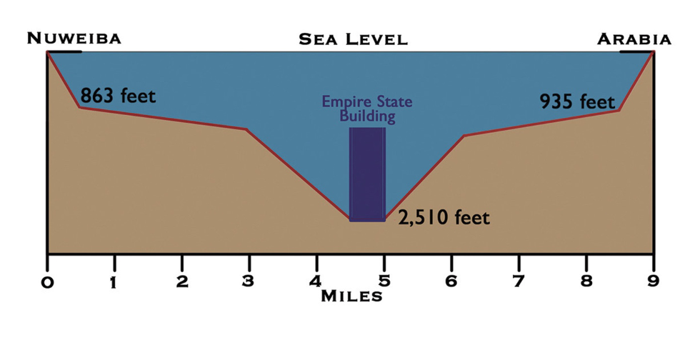
What we have not been told in the books and videos is that the British Admiralty have determined the greatest depth of water on the ‘land bridge’ by sonar soundings to be 765 metres (2,510 feet), twice the height of the Empire State Building. In addition to that fact, the saddle or land bridge drops quickly from the shore to depths of 263 metres (863 feet) on the Western side and 284 metres (935 feet) on the Eastern side. Making the descent and ascent respectively next to impossible. Especially for the old people, women and children who were certainly in the group of Israelites crossing the waters.

The more major feature of this theory I have a difficulty with is the journey from Avaris to Pi-Hahiroth.
After leaving Rameses, the Israelites set up camp at Succoth. Then they left Succoth and camped at Etham on the edge of the wilderness. They left Etham and turned back toward Pi-hahiroth, opposite Baal-zephon, and camped near Migdol. They left Pi-hahiroth and crossed the Red Sea into the wilderness beyond. Then they traveled for three days into the Etham wilderness and camped at Marah.
Numbers 33:5-8
The text of Numbers 33 almost requires the camps to be a short distance between each other. Yes it is true that they could well have travelled at night, but it seems as though the camps were within easy reach of each other. The likelihood of the pursuing Egyptian troops in chariots requires distance to be set quickly between the exodees and their pursuers. To require those fleeing the Egyptians to cross the whole of the Sinai Peninsula until the far side at the western edge of the Gulf of Aqaba is a big ask. Particularly when there were only three camps between Rameses and the crossing. Also in my mind we need to account for all the other camps following the crossing and these need to be in the order given in Numbers 33 and need to include the gold standard sites of Kibroth Hattaavah and Rephidim before they reach Mt Sinai.
I will include a discussion on this matter when we look at the next suggested route – The Potential Exodus Route 6. The problem of the number of camps and their locations relates to the 6th potential route as well. Added to that are the locations of the camps after leaving Mt Sinai / Mt Horeb. It is this factor which cause a number of experts to write “any attempt to map the Exodus route is doomed to failure”, especially where the locations of the places following Sinai are concerned.” All of this complexity needs to be taken into account. Apart from David Rohl’s most recent work Exodus: Myth or History, I have examined upward of 10 hours of video from Timothy Mahoney’s series of videos on Patterns of Evidence and followed up with a number of other books which include the latest publication from Doug Petrovich, Origins of the Hebrews: New Evidence of Israelites in Egypt From Joseph To The Exodus. It goes without saying that there is more to come.
Next Nugget: The South Eastern Tiran Straits Route (Potential Exodus Route 6)
