I will now begin to evaluate each of the potential Exodus routes I gave you in the last Nugget as to the possibility of each one being the route most likely to fit all the facts. I told you there are two key locations which we have to take into account in order to plot the most likely route. They are the positioning of Pi-Hahiroth and Baal Zephon in relationship to Mt Sinai. In the Nugget I wrote related to The Problem of Locating Pi-Hahiroth I gave you the location points for these two key location factors from the various atlases.
In Gem 2063 I gave you the map which Tim Dowley includes in both the Candle Atlas and The Baker Atlas of Christian History, both of which give you the route marked as the Way to the land of the Philistines. This is effectively The Mediterranean Coast Exodus Route 1. In Gem 2063 I wrote: Why does the Exodus route go north from Rameses to Succoth, the Reed Sea, Etham and then to points south past the Bitter Lakes? That is curious to say the least. Why would the people of Israel travel north from Goshen into the area mentioned above. The suggestion in the maps is that they left the area of Avaris where there was likely a heavy population of Asiatic people (Hebrews) according to David Rohl and headed north out of the area of the Faiyum. David Rohl, in conjunction with Manfred Bietak, has established that Tel ed-Daba is the most likely location for Joseph’s place in relation to the ancient city of Avaris. You can find the location where David Rohl places Tel ed-Daba (Avaris) on the map below marked with a yellow X.
Why would they move into the Delta area, heavily populated and likely to be a trap for them? They would not likely take the top two northern routes: The Way to the Land of the Philistines or the Way to Shur as marked on the Candle and Baker maps, because that would take them through the Levant, the popular route through the fertile crescent around the Mediterranean Sea. Why would the fleeing Israelites go that way? To go into the Nile Delta region and then follow the route through the Levant would in my opinion be asking for trouble and capture from the pursuing Egyptians. They are more likely to head south and cross the wilderness areas across the Sinai Peninsula.
Notice the location of the Reed Sea at the top of the Delta close to the Mediterranean. What would that give them access to? Absolutely nothing. Why is Baal Zephon located up there? Pi-Hahiroth was the first place on the near side of the Yam Suph as they stood facing the daunting prospect of crossing the water. Baal Zephon was the place they crossed over to, after the LORD parted the waters for them. So the locations on these maps are questionable and make no sense. Oh I will suggest why the idea is that they headed in that direction: in order to take them to places that could be called the Reed Sea. The Reed Sea is supposedly the meaning of the Hebrew for [Yam Suph] (Red Sea).
The positioning of Pi-Hahiroth and Baal Zephon, mark the location of the crossing point. So these two markers and the body of water between them are crucial evidence of the likely location for the point of crossing over the Yam Suph. Hence in Gem 2063 I pointed out the vain attempts to locate these two places in the north. It makes no sense to look around the coast of the Mediterranean for the location of Mt Sinai as indicated on the map below. In order to choose the Mediterranean Coast Route we would have to select one of the three southern locations for Gebel Helal as the location of Mt Sinai, or more likely the more northern site of Jebel Helal, after Dowley and Wyart’s atlas (1997). (Yes that is the same Tim Dowley, the editor of the two atlases mentioned above.) I have taken all these factors into account in my attempt to give you a map which pulls all of this together.
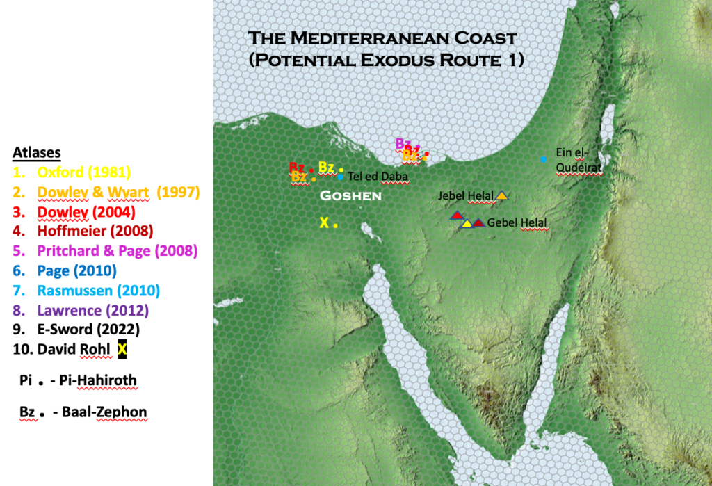
The location of Ein el-Qudeirat (Kadesh Barnea) which is most likely to fit this scenario comes from Rasmussen’s atlas. Many theorists in forming their conclusions on the most likely route, choose Ein el-Qudeirat as the place most likely to be Kadesh Barnea. But interestingly, in doing so, end up with multiple locations as to where Kadesh Barnea or its equivalent is likely to be. Whenever that happens, it tells me that nobody really knows, which is in accord with what William Dever and K.A. Kitchen say, especially in the case of any locations on the journey after Sinai.
I haven’t gone so far as to plot the actual locations of places according to this theory as it seems too highly speculative. Not only that, it seems to me that the proponents of this theory (listed in last Nugget) are those who following the lead of the German text critical period who regard the Yam Suph as being just ‘a sea of reeds’ and hence their desire to locate it somewhere in the Nile delta. But I do believe that I have given you all the relevant information for you to evaluate the likelihood of the Mediterranean Route being the most likely route for the Exodus.
In my humble opinion it is highly unlikely.
Common sense says the Israelites would be much more easily caught by the pursing Egyptians if they went north! And let us not forget they had 40 years to wander the desert to pay for their sin, and while doing so doing a new generation would emerge to enter the Promised land with no recollection of the customs and the culture of Egypt.
That Ross is indeed a truism.
For me, the important foundation question is “Where was Midian for Moses?”
It was in Midian as a shepherd that Moses was drawn to the burning bush and met up with the God he had been protected by in all his life!
God’s word to him at the burning bush was to go to Pharaoh and declare God’s desire and instruction to Pharaoh: “Let my people go”.
God then promised Moses that he would return to “this mountain” and worship God there.
It sounds like Sinai was in Midian.
It sounds like Midian was a separate entity, not under Egyptian rule, as Moses fled from Pharaoh. (He would have needed to get out of Egyptian control locations!)
So where was Midian at that time?
My understanding is that Egypt controlled all of the Sinai Peninsula at that time, or was that just later on, until the Romans took over?
Midian was located on the east side of the Gulf of Aqaba, modern day Iran.